Global geothermal intelligence
Find geothermal opportunity anywhere on Earth.
A machine-learning powered geothermal intelligence platform. We combine global subsurface data, probabilistic 3D thermal modeling, and uncertainty-aware prospect ranking so teams can identify where geothermal development is most worth investigating.
Platform
A global intelligence platform for geothermal prospectivity.
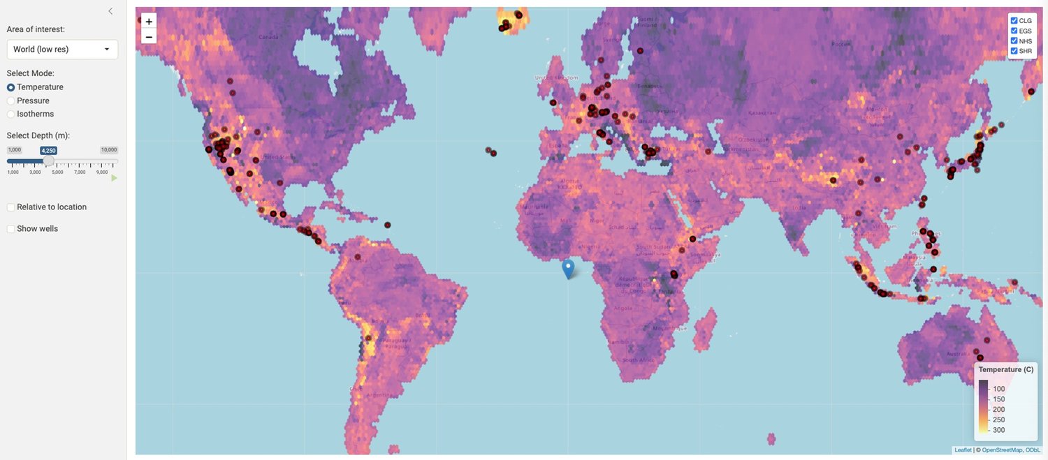
Geothermal Radar integrates geothermal-relevant evidence into a probabilistic 3D view of subsurface thermal opportunity. The output is not another static map — it is a decision-support system for ranking geothermal opportunities and understanding the uncertainty behind each one.
Global geothermal evidence
A broad and growing collection of geothermal, subsurface, thermal, spatial, and proprietary analytical layers, structured into one intelligence environment.
Probabilistic 3D thermal modeling
Estimates of deep thermal conditions and their uncertainty across the depth ranges relevant to EGS, superhot rock, closed-loop, and conventional geothermal.
Prospectivity ranking
Compare sites, regions, and project concepts using model-guided geothermal prospectivity scores designed to support expert review and next-step planning.
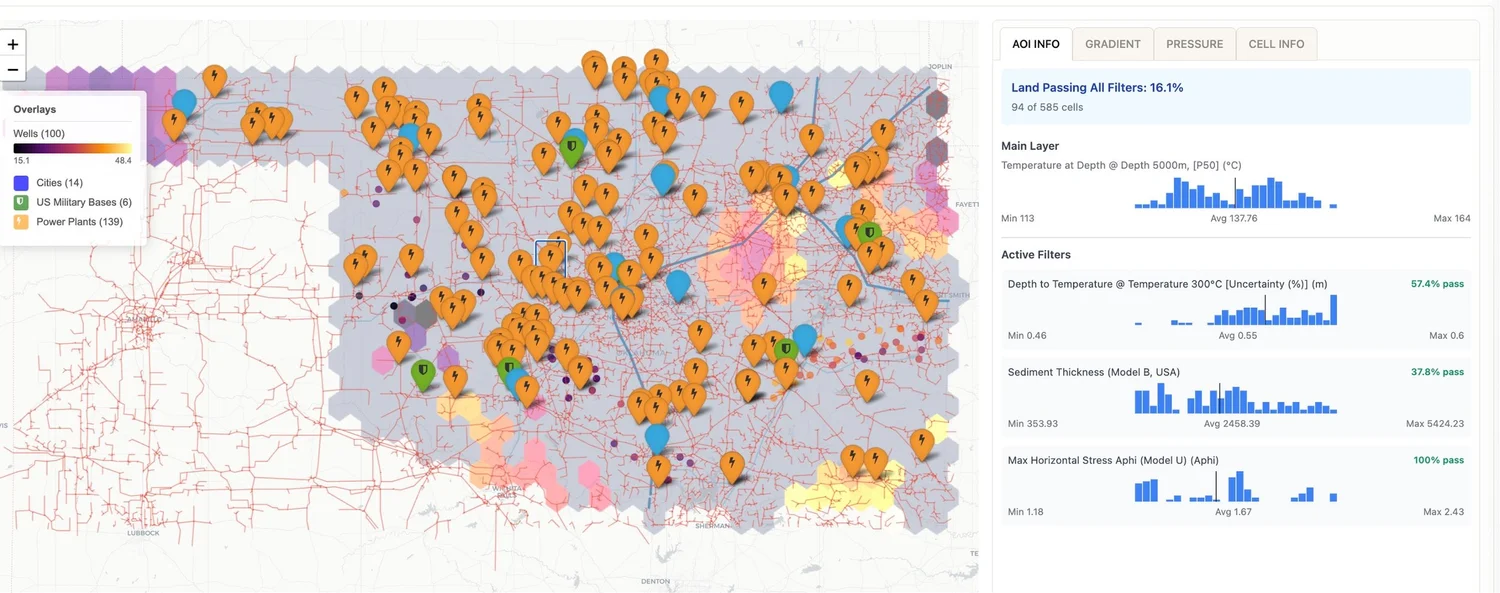
Narrow a region. See what passes.
Filter locations by temperature at depth, sediment thickness, stress regime, infrastructure context, and more — with pass rates updated as filters change.
How it works
From global data to decision-ready geothermal intelligence.
The workflow is built for high-stakes early decisions: integrate evidence, model thermal conditions, quantify uncertainty, rank opportunities, and focus the next diligence step.
Integrate evidence
Geothermal-relevant evidence pulled together across regions, depths, and data types — including measured thermal data where available.
Model conditions
Spatial, statistical, stochastic, and probabilistic models estimate the 3D thermal profile and geothermal prospectivity.
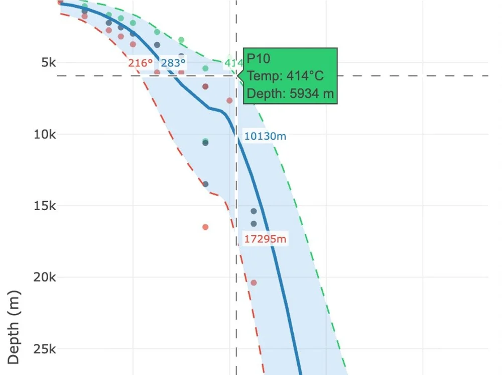
Quantify uncertainty
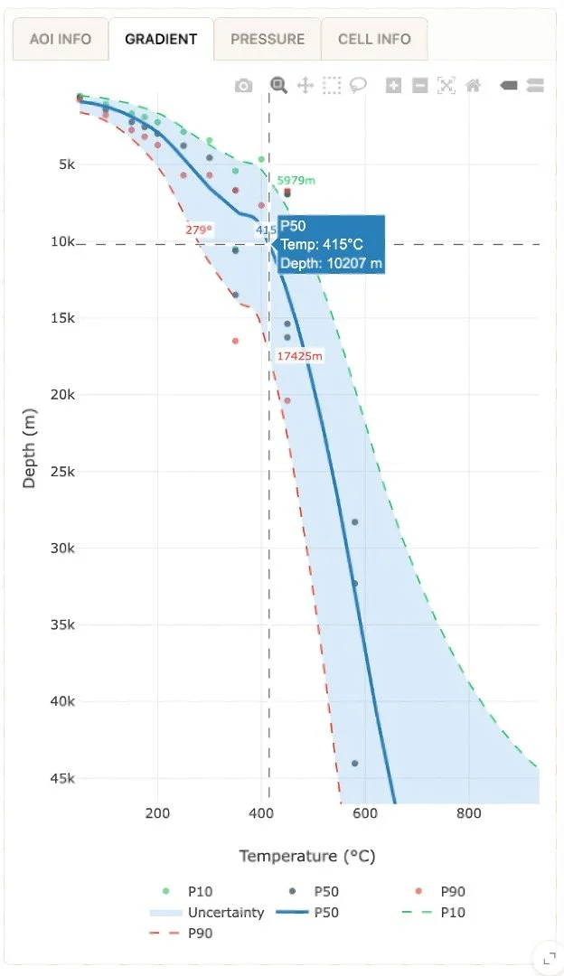
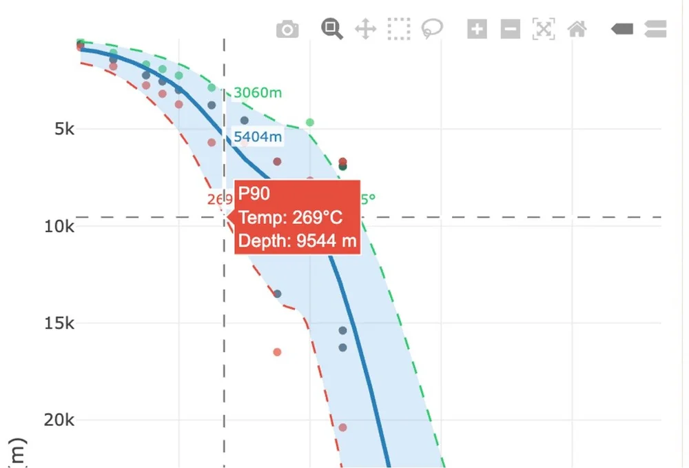
GRMS-aligned P10, P50, and P90 views show where evidence is stronger, where it is missing, and how that should shape the decision.
Rank opportunities
A consistent prospectivity framework that supports screening, diligence, and strategic comparisons across very different regions.
Focus the next move
Decide what to investigate next: fieldwork, partnerships, data acquisition, investment review, or project-specific engineering.
Location depth
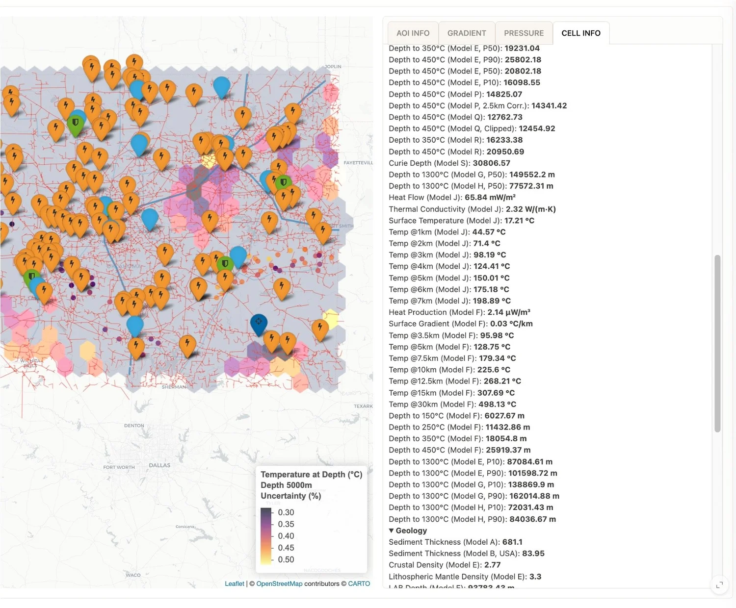
Inspect every location — surface to deep thermal state.
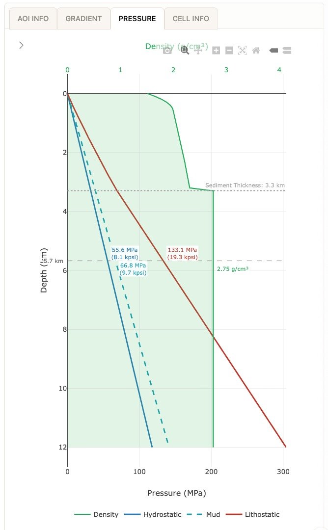
Each location carries a structured set of attributes: temperature at depth, heat flow, surface temperature, sediment thickness, conductivity, lithology, stress regime, and more. Outputs are exposed to expert review without hiding the underlying model logic.
One location, dozens of model layers.
Geothermal Radar pulls together a deep stack of geothermal, subsurface, and engineering attributes for every location — readable, comparable, and ready for technical interrogation.
Uncertainty, made explicit
Every prediction comes with its uncertainty range.
Temperature-at-depth is not given as a single number. Geothermal Radar reports GRMS-aligned P10, P50, and P90 views — best, central, and conservative scenarios — so teams can see how the model thinks, not just what it concludes.
AI and machine learning
Applied machine learning, not AI hype.
For Geothermal Radar, AI is not a chatbot. It is applied machine learning and probabilistic modeling that integrate complex, incomplete earth data into better prospectivity ranking, uncertainty estimation, and exploration decisions.
- The meta-model learns from new public, proprietary, and client data points, updating the inferred thermal profile and the uncertainty around it.
- The platform makes geothermal screening more consistent, evidence-rich, and explainable for the experts who use it.
- It is not a substitute for geologists, engineers, drilling, field validation, or project-specific reservoir analysis.
- It helps teams decide where to look first, what to compare, and which evidence to pursue next.
Technology
Built for the complexity of the subsurface.
Geothermal Radar models deep thermal conditions across the globe, including the depth ranges relevant to enhanced geothermal systems, superhot rock, closed-loop concepts, and conventional geothermal. The probabilistic 3D thermal framework extends up to 1300 degrees Celsius and is designed to work in both data-rich provinces and frontier regions where direct measurements are limited.
The platform combines measured thermal evidence where available, aggregated subsurface and thermal models, proprietary analytical layers, spatial and stochastic modeling, and a learning meta-model that updates as new public, proprietary, or client data becomes available.
One of the most comprehensive global geothermal datasets.
A broad model suite and analytical foundation focused on geothermal prospectivity screening, without exposing proprietary inputs or calculation details.
Uncertainty-aware by design.
Geothermal Radar shows where confidence is stronger, where evidence is missing, and how GRMS-aligned P10, P50, and P90 views inform interpretation.
Designed around GRMS-style resource thinking.
Built for quantitative geothermal evaluation with uncertainty views familiar to technical teams already working inside GRMS-style frameworks.
Who it is built for
Built for the teams making geothermal decisions.
Technical teams who need depth, executives who need clear decision value, and reviewers who need credible boundaries around what the platform actually does.
Screen acreage and prioritize diligence.
Compare prospects, identify stronger starting points, and focus technical effort before committing to costly site-level programs.
Assess regional geothermal strategy.
Evaluate opportunity across countries, basins, concessions, and development corridors with consistent model-guided intelligence.
Find firm clean-power potential.
Understand where EGS, superhot rock, closed-loop, or conventional geothermal can support strategic load growth and firm clean power procurement.
Explore power and heat options.
Screen geothermal potential near industrial demand, process-heat needs, and infrastructure constraints, with particular relevance for EGS and high-temperature concepts.
Compare opportunities before capital decisions.
Review opportunity quality, uncertainty, and the next evidence needed before committing capital or partnership resources.
Evaluate potential across jurisdictions.
Support geothermal resource assessment, policy planning, competition review, and public-sector energy strategy.
Where it fits
Built to inform the highest-stakes decisions, not replace the experts who make them.
Geothermal Radar earns its place at the front of the workflow. It hands off cleanly to engineering, fieldwork, and the people who know the rock.
Informs decisions
A stronger starting point for screening, diligence, investment review, and strategic planning — more disciplined than ad hoc spreadsheets, deeper than a static map.
Respects your experts
Outputs are made for geologists, engineers, and decision-makers — readable, uncertainty-aware, and grounded in evidence, not black-box scores.
Focuses the next move
The platform is built to help decide where to look first, what to investigate next, and which evidence is worth seeking.
Get in touch
See what Geothermal Radar can show you.
Whether you are screening a region, evaluating a site, comparing development options, or shaping geothermal strategy for EGS, superhot rock, closed-loop systems, or firm clean power — Geothermal Radar can help you understand where to look first and what to investigate next.